Best Spring Hiking Trails at Grand Canyon
Discover the best spring hiking trails at Grand Canyon, from rim walks to short below-the-rim adventures. Explore scenic viewpoints, seasonal highlights, and practical tips to help you plan a safe and rewarding visit.
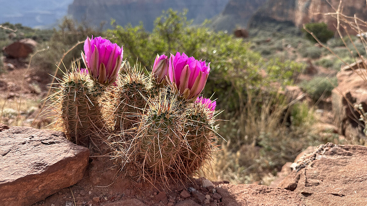
Spring is one of the most rewarding times to hike at Grand Canyon. As winter snow begins to melt and temperatures warm along the South Rim, the canyon feels especially inviting. Desert plants begin to bloom, wildlife becomes more active, and crisp spring air makes longer walks far more comfortable than during the intense heat of summer.
For visitors searching for the best hikes Grand Canyon offers, spring provides ideal conditions, particularly for those new to hiking or visiting the canyon for the first time!
Many of the most memorable experiences happen along the rim. Scenic overlooks, interpretive paths, and quiet viewpoints allow visitors to appreciate the canyon’s vast scale without committing to a strenuous backcountry trek.
This guide highlights several of the best spring hikes Grand Canyon visitors can explore during spring 2026, along with helpful tips for planning a safe and rewarding visit.
Why Spring Is the Best Season for Hiking
Spring temperatures along the South Rim typically range between 40 and 70 degrees Fahrenheit, making it one of the most comfortable times of year to hike. There is still a possibility of snow or icy patches along shaded trails, so be sure to check the weather forecast before you arrive!
Beyond pleasant temperatures, spring offers several advantages for hikers:
- Comfortable daytime hiking conditions
- Fewer crowds compared to peak summer months
- Wildflowers beginning to bloom along the rim
- Increased chances of wildlife sightings
- Full access to shuttle routes and park service
Conditions can still change quickly in the canyon. Sudden winds, afternoon storms, or lingering ice are always possible, so always check trail conditions before heading out.
Understanding Canyon Hiking Basics
One of the most important things to remember when hiking at Grand Canyon is simple but easy to overlook:
Going down is optional. Hiking back up is mandatory.
The canyon’s dramatic elevation changes can make the return climb much more difficult than expected, especially for visitors unfamiliar with desert environments. Even shorter hikes should be approached with thoughtful pacing, plenty of water, salty snacks and an awareness of weather conditions.
Many first-time visitors find that the most meaningful experiences come not from hiking deep into the canyon, but from taking time to explore scenic viewpoints and educational trails along the rim.
For hiking preparation and safety guidance, check the following park resources:
Top Hiking Trails at Grand Canyon
Rim Trail
Distance: Up to 13 miles (walk any section)
Best For: Scenic views, flexibility, and first-time visitors
The Rim Trail is often considered one of the best hikes Grand Canyon offers for beginners. Running along the edge of the canyon between Hermits Rest and the South Kaibab Trailhead, this trail provides continuous views while remaining relatively flat and accessible.
Many sections of the trail are paved, making them suitable for a wide range of visitors. Because shuttle stops are located along the route, hikers can easily explore one section of the trail and return using park transportation.
Popular segments include:
- Mather Point to Yavapai Geology Museum
- Grand Canyon Village to Hopi Point
- Verkamp’s Visitor Center to Trail of Time
Interpretive signs along the trail explain the canyon’s geology, wildlife, and cultural history, turning a simple walk into a deeper learning experience.
More information: https://www.grandcanyon.org/experience-grand-canyon/hiking/
Trail of Time - Fully Accessible!
Distance: About 2.8 miles round trip
Best For: Learning about canyon geology
The Trail of Time transforms a walk along the rim into a journey through nearly two billion years of Earth’s history.
Along the trail, large stone markers represent layers of geologic time. As visitors walk west along the rim, each step represents millions of years of geological change that shaped the canyon’s towering cliffs and rock layers.
Because the path is paved and relatively level, it is one of the most accessible ways for visitors to connect with the canyon’s ancient past.
For those interested in exploring canyon geology even further, Grand Canyon Conservancy Field Institute programs offer guided geology walks led by educators.
Learn more about Field Institute programs: https://www.grandcanyon.org/field-institute/
Shoshone Point
Distance: About 2.1 miles round trip
Best For: Quiet views away from crowds
For visitors looking to experience a quieter side of the South Rim, Shoshone Point offers a peaceful alternative to some of the canyon’s busier viewpoints.
The trail follows a mostly flat dirt road through pinyon and juniper forest before opening to a dramatic rim overlook. The viewpoint provides wide, unobstructed canyon views and is especially beautiful at sunrise or sunset.
In spring, the surrounding forest often comes alive with blooming wildflowers and migrating birds.
Desert View Scenic Walks
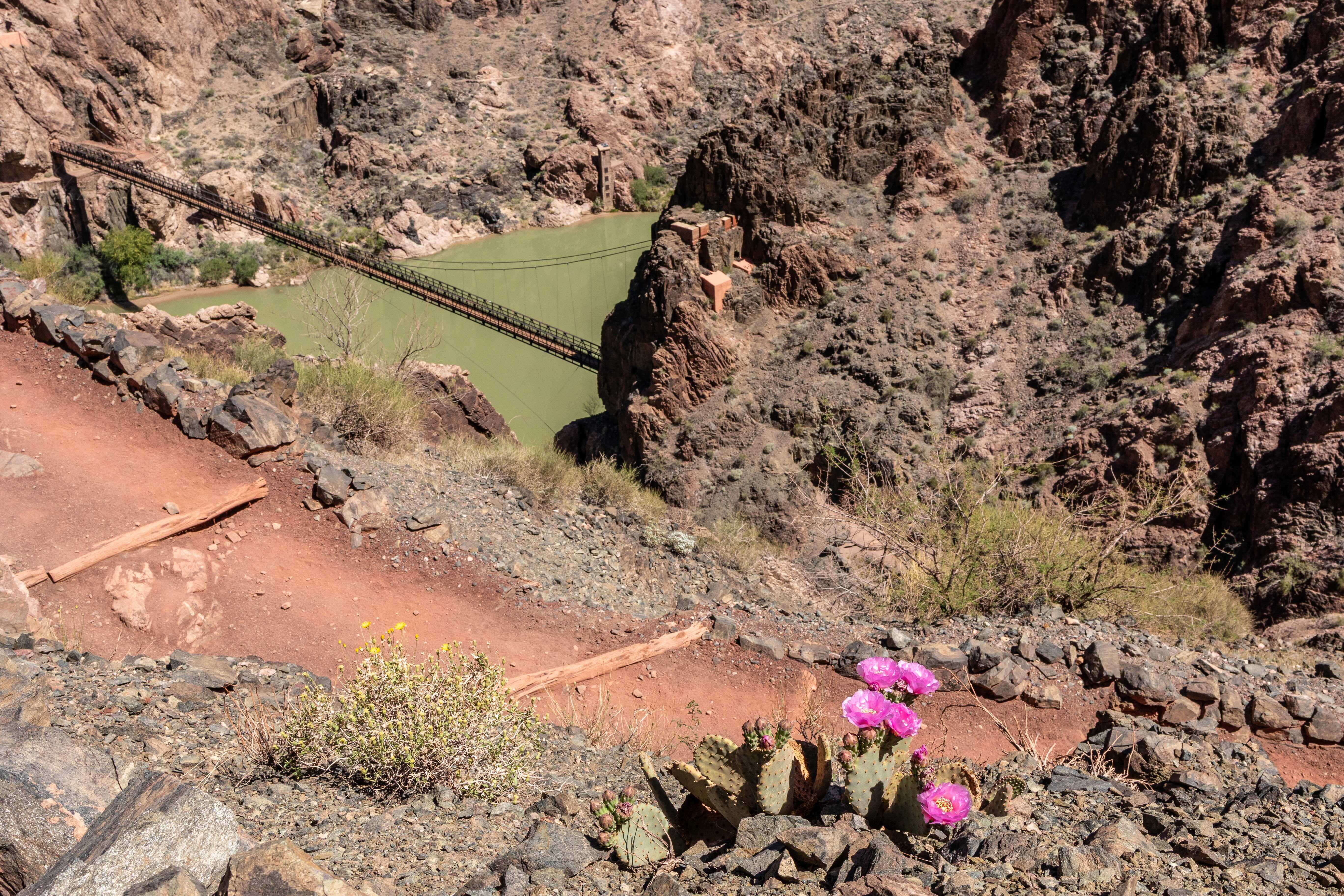
Not every canyon experience requires a long hike. Several overlooks along Desert View Drive offer short scenic walks with sweeping views of the canyon and the Colorado River far below.
Some notable stops include:
- Lipan Point
- Moran Point
- Navajo Point
- Desert View Watchtower
These locations provide incredible panoramic views while requiring only short walks from parking areas, making them excellent options for first time visitors at Grand Canyon.

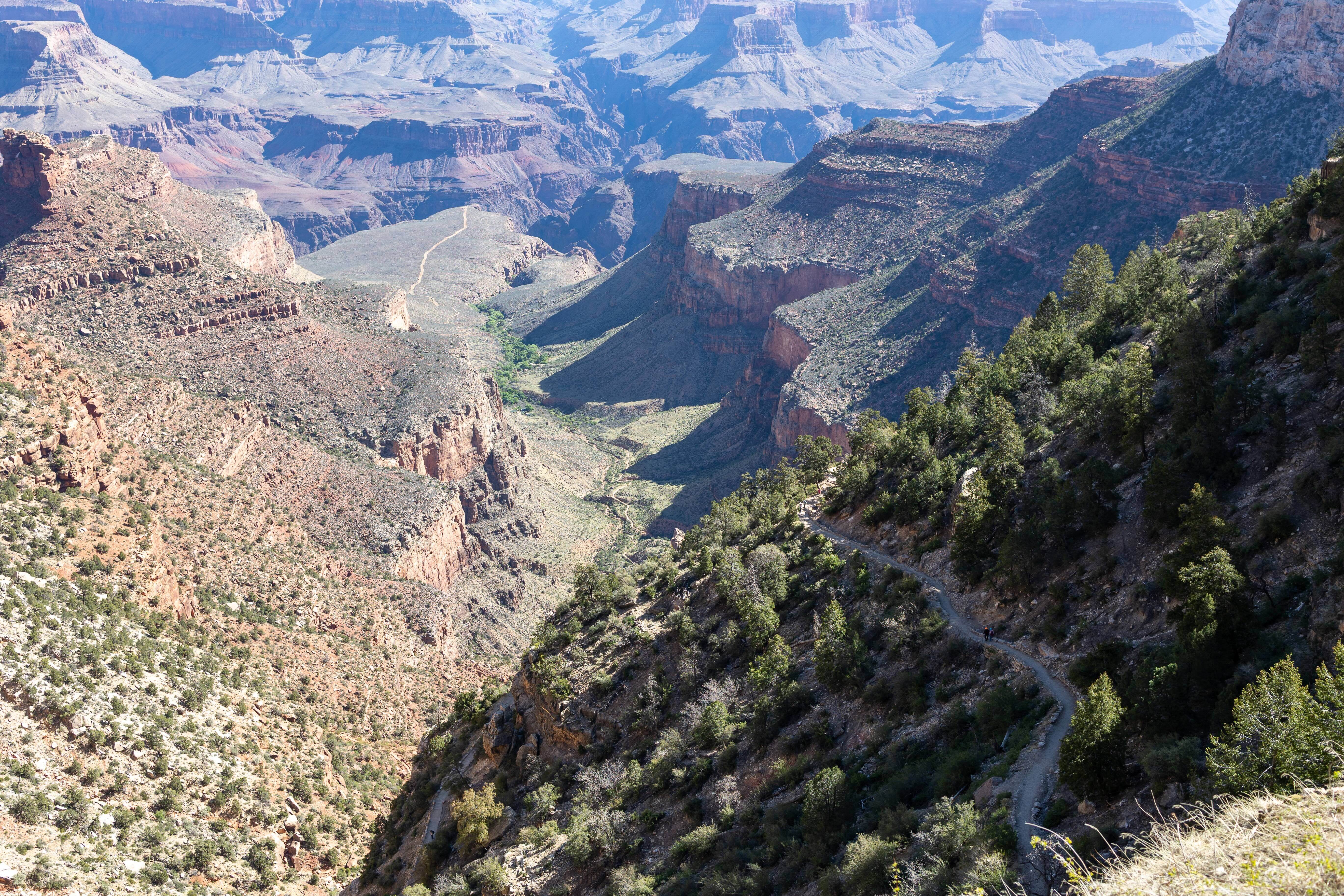
Bright Angel Trail
Best For: Experiencing the canyon from below the rim
For visitors who want a brief taste of hiking below the rim, the upper section of Bright Angel Trail offers one of the most memorable introductions to the inner canyon. Descending even a short distance reveals dramatic shifts in perspective, from sweeping rim views to close-up encounters with the canyon’s layered rock formations and desert vegetation.
How far you choose to hike should depend on your comfort level, current weather, and trail conditions. It is essential to allow ample time for the steady climb back to the rim. Carrying sufficient water, pacing yourself, and avoiding the hottest hours of the day are critical.
Key turnaround points and rest stops along the upper trail include:
- First Tunnel
0.1 miles (0.2 km) roundtrip • About 20 minutes - Second Tunnel
1.8 miles (2.9 km) roundtrip • 1 to 2 hours • Approximately 590 feet (180 m) elevation change - Mile-and-a-Half Resthouse
3 miles (4.8 km) roundtrip • 2 to 4 hours • About 1,120 feet (340 m) elevation change
Water availability varies. Check the National Park Service website before hiking. - Three-Mile Resthouse
6 miles (9.6 km) roundtrip • 4 to 6 hours • About 2,120 feet (645 m) elevation change
Water availability varies. Check the National Park Service website before hiking. - Havasupai Gardens
9 miles (14.4 km) roundtrip • 6 to 9 hours • About 3,040 feet (925 m) elevation change
Attempting this distance as a day hike is strenuous. Consult a park ranger before planning this route. Water availability varies.
South Kaibab Trail to Ooh Aah Point
Best For: A short below-the-rim adventure with dramatic views
For visitors who want to experience hiking below the rim without committing to a long descent, the South Kaibab Trail to Ooh Aah Point is one of the most rewarding options. The trail follows a well-maintained ridge line route that quickly opens to expansive views of the canyon’s layered rock formations and vast interior landscape.
Within less than a mile, hikers reach Ooh Aah Point, a viewpoint that lives up to its name with sweeping panoramas stretching deep into the canyon. Because the trail travels along an exposed ridge, it offers wide views in multiple directions and some of the most dramatic early perspectives available from below the rim.
How far you continue should depend on your experience level, weather conditions, and available time and energy for the climb back to the rim. Key turnaround points include:
- Ooh Aah Point
1.8 miles (2.9 km) roundtrip • 1 to 2 hours • About 790 feet (230 m) elevation change - Cedar Ridge
3 miles (4.8 km) roundtrip • 2 to 4 hours • About 1,120 feet (340 m) elevation change - Skeleton Point
6 miles (9.6 km) roundtrip • 4 to 6 hours • About 2,040 feet (620 m) elevation change
Hiking below Skeleton Point is generally not recommended as a single-day outing due to the long distance, extreme temperature changes, and an elevation change of roughly 5,000 feet (1,500 m) each way. Visitors planning longer hikes should speak with a park ranger for safety guidance and information about required overnight permits.
Even on shorter hikes, visitors should carry plenty of water, wear sturdy footwear, and avoid the hottest hours of the day. In spring, blooming desert plants and increased wildlife activity can add to the experience, while clear morning light often makes sunrise one of the most memorable times to explore the trail.
Guided Hiking Through Field Institute
Hiking at Grand Canyon becomes even more meaningful when paired with expert interpretation.
Through Grand Canyon Conservancy’s Field Institute, visitors can join guided programs that explore the canyon’s geology, ecology, cultural history, and wildlife.
Programs range from short educational walks to immersive multi-day courses and often include opportunities to learn directly from scientists, naturalists, and cultural experts.
Field Institute programs include:
- Geology hikes
- Cultural history walks
- Ecology and wildlife programs
- Multi-day educational courses
Explore upcoming programs: https://www.grandcanyon.org/field-institute/
Hiking Safety Checklist
Before starting any hike at Grand Canyon, it’s important to prepare properly.
Always view the Hike SMART Guide before going on your journey.
Helpful tips include:
- Carry at least one liter of water per person
- Wear sturdy, supportive footwear
- Bring sun protection such as hats and sunscreen
- Take frequent breaks to refuel on snacks and conserve your energy
- Check weather forecasts and trail conditions
- Allow time for rest breaks and the return climb
Stay Connected
Every season brings new opportunities to explore and learn at Grand Canyon.
Grand Canyon Conservancy shares updates on hiking conditions, educational programs, and conservation efforts throughout the year.
Join the email list to stay connected. Subscriptions help support preservation, research, and educational programs that protect Grand Canyon for future generations.
Frequently Asked Questions About Spring Hiking at Grand Canyon
What are the best hikes at Grand Canyon in spring?
Some of the best spring hikes at Grand Canyon include the Rim Trail for easy, scenic views, the Trail of Time for geology-focused walks, Shoshone Point for quieter viewpoints, and short descents on Bright Angel Trail or South Kaibab Trail. These options offer a mix of accessibility, scenery, and flexibility depending on your experience level.
Is spring a good time to hike Grand Canyon?
Yes, spring is one of the best times to hike Grand Canyon. Temperatures typically range from 40 to 70 degrees Fahrenheit along the South Rim, making conditions far more comfortable than summer. Visitors can also enjoy blooming wildflowers, fewer crowds, and increased wildlife activity.
How difficult is hiking at Grand Canyon?
Hiking at Grand Canyon can be more challenging than expected due to steep elevation changes. While going down into the canyon may feel easier, the return hike back up is physically demanding. Even short hikes require preparation, pacing, and plenty of water.
Do I need a permit to hike at Grand Canyon?
No permit is required for day hiking on maintained trails like the Rim Trail, Bright Angel Trail, or South Kaibab Trail. However, permits are required for overnight backcountry hiking or camping below the rim.
What should I bring for a spring hike at Grand Canyon?
For a safe and enjoyable hike, bring:
• At least one liter of water per person
• Salty snacks or energy food
• Sun protection (hat, sunscreen, sunglasses)
• Sturdy hiking shoes
• Layers for changing temperatures
• A map or trail information
Spring conditions can vary, so it’s important to be prepared.
Are Grand Canyon trails open in spring?
Most South Rim trails and shuttle routes are open in spring, but conditions can change due to weather. Snow, ice, or temporary closures may occur, so it’s important to check trail status before your visit.
What is the easiest hike at Grand Canyon?
The Rim Trail is considered one of the easiest hikes at Grand Canyon. It is relatively flat, partially paved, and offers continuous canyon views. Many sections are accessible and can be customized based on time and ability.
Can beginners hike below the rim at Grand Canyon?
Yes, beginners can hike below the rim on trails like Bright Angel Trail or South Kaibab Trail, but only for short distances. Popular turnaround points like Ooh Aah Point or the First Tunnel provide a great introduction without requiring a full descent.
How much water do I need for a Grand Canyon hike?
A general guideline is to carry at least one liter of water per person for shorter hikes, but more may be needed depending on distance, temperature, and effort. Water availability along trails can vary, so always check ahead.
Are there guided hiking tours at Grand Canyon?
Yes, guided hiking programs are available through the Grand Canyon Conservancy Field Institute. These include geology hikes, cultural history walks, and multi-day educational experiences led by experts.


